Getting found: signaling, calling, waiting in the right place
A well-aimed mirror carries further than a flare. Staying put gets you found faster than running. Here is what search and rescue teams wish you knew before they arrive.
It’s 3 p.m., you’ve stopped because you haven’t recognized anything for ten minutes. The reflex is to move, walk faster, find something recognizable. The correct reflex, statistically, is almost always the exact opposite: stop, make yourself visible, and let search teams do what they do best. This module isn’t about how to avoid getting lost—that’s what the navigation module covers—it’s about what happens once you are: who comes looking for you, how, and what you can do, step by step, to cut that wait down from several hours to a few minutes.
Who looks for you, and how
In France, whenever a search operation is launched in the mountains or forests, high-mountain gendarmerie platoons (PGHM) or departmental fire and rescue services (SDIS) are usually deployed, backed by civil protection for air assets. The PGHM, created after WWII, currently counts 289 military personnel and 69 civilians spread across 21 platoons in the Alps, Pyrenees, Corsica, and Réunion Island, including 125 high-mountain guides. Since their inception, they have carried out over 40,000 missions and rescued nearly 50,000 people, averaging about 5,400 operations per year—1,500 in the Chamonix sector alone. A portion of their operations now relies on a geolocation app, GendLoc, which helps locate a lost hiker using their smartphone.
A search operation actually deploys several tools simultaneously, not just one:
- Dogs work using two distinct methods. Tracking dogs follow a specific scent left on the ground by a specific individual’s passage; air-scenting dogs detect any human scent carried by the wind, making them much more effective for sweeping a large area without a known trail. Their training starts around 10 to 12 weeks of age and spans 12 to 18 months, requiring 20 or more hours per week—and their efficiency depends as much on the dog as on the bond with their handler, the weather, and ground humidity.
- Helicopters quickly cover large areas and can directly winch an otherwise inaccessible victim, but they are blind under a dense canopy and deaf to a whistle—which is why large, high-contrast visual signals aimed at the sky are so vital.
- Drones, increasingly used by ground search teams, carry high-resolution thermal cameras capable of spotting a warm outline at night or under light cover; some British lowland search and rescue teams use them both to locate missing persons and map active wildfires.
- Human foot grids remain the slowest but most thorough method: lines of volunteers or rescuers sweeping an area meter by meter when a precise clue (a piece of clothing, a footprint) narrows down the likely zone.
None of these assets are deployed randomly: they follow a probability framework built around a specific starting point, known in search operations as the Last Known Point (LKP).
What 183,000 search cases revealed
Robert Koester, an American researcher, spent over forty years compiling the International Search and Rescue Incident Database (ISRID), which now aggregates data from over 183,000 search incidents worldwide. His book Lost Person Behavior (2008) remains the benchmark for search teams addressing a very practical question: where should we look first, depending on who is lost?
Koester categorizes missing persons into distinct groups—hikers, hunters, children (broken down into three-year age brackets up to 15), people with dementia, individuals in psychological distress, mountain bikers, skiers, and a dozen others—because each profile behaves differently once disoriented. A hunter focused on tracking a trail will wander further and longer than a hiker; a child under six tends to hide or stay near a familiar landmark; a person with dementia often follows old, familiar routes, sometimes miles away from where they lived decades prior.
Koester also outlines several typical strategies observed in lost individuals: following a randomly picked trail (route travelling), holding a constant heading without knowing if it’s correct (directional travelling), staying at a constant elevation along a slope (contouring), or seeking civilization by heading downhill—or conversely, climbing higher to catch cell service. The most common decision points where people get lost are trail junctions and sharp bends: past these points, most people keep going straight in their initial direction, even when something “feels off,” rather than turning back.
Staying put: the rule almost nobody follows
Every wilderness safety program preaches the same rule: once you realize you’re lost, stay put. Canadian researcher Kenneth Hill wanted to find out if people actually follow this advice. He analyzed over 800 missing person cases in Nova Scotia. The result: only two people deliberately chose to stay still to make themselves easier to find. One was an 11-year-old boy who had taken the Hug-A-Tree program at school; the other was an 80-year-old woman who simply sat down five minutes after realizing she was lost, barely a hundred meters from where she had stepped off the trail.
Every other case in the database followed the same pattern: the individual kept walking, convinced safety was “just over the next hill” or “around the next bend.” The emotional shock of realizing you are lost directly impairs judgment, even among experienced outdoor enthusiasts—a mental mechanism detailed further in the mindset module.
The Hug-A-Tree and Survive program, created in San Diego following the tragic loss of a nine-year-old boy in the woods, turned this concept into an educational framework for kids: “hug a tree” as soon as you realize you’re lost, stay near it, use a whistle instead of your voice (which travels poorly and drains energy quickly), keep a trash bag in your pack to stay warm and dry, wear bright clothing if possible, and lie down on the ground if a helicopter approaches so your outline stands out—standing and moving, a silhouette blends into surrounding vegetation from above.
Before you head out: the trip plan that slashes search times
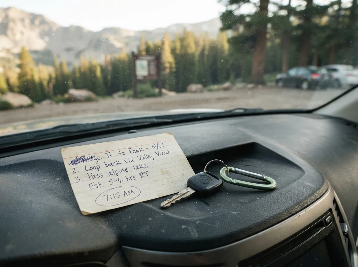
The entire search apparatus relies on a single trigger: the moment someone realizes you haven’t returned. The earlier this happens, and the more accurate your Last Known Point is, the faster the search begins and the tighter the focus area becomes. Leaving a plan is the single most effective action in this module, and it costs nothing.
- Write down your exact route: starting point, intended path, destination, and any planned alternatives if you alter your route along the way.
- Set a firm return time, along with a hard deadline for when someone should worry and call emergency services—not “sometime in the evening,” an exact time.
- Leave a copy with a contact via text or call, and place a second copy on your car dashboard or at your starting trail shelter: search teams check these locations first.
- Specify group size and gear carried (tent, sleeping bag, days of food): this directly shapes how emergency teams gauge the level of urgency.
- Enable a location sharing app on your phone if supported, ensuring a GPS trace exists even if you can no longer place a call.
To share a precise location with someone unfamiliar with GPS coordinates, the what3words system divided the globe into 57 trillion three-meter squares, each identified by a unique three-word combination—over 85% of UK emergency services were using it by 2021. It is easy to dictate over the phone, but it is not infallible: in London, roughly one in 24 addresses can be confused with another due to similar-sounding plural and singular words, and Mountain Rescue England and Wales documented 45 incorrect locations in a single year. Use it as a secondary check alongside standard GPS coordinates, never as a standalone tool for life-threatening calls.
Pushing your phone to its limits
A phone showing no signal bars isn’t necessarily useless. 112, the European emergency number, is built into the GSM standard: a compatible smartphone can dial this number even when locked, and in certain regions, even without a SIM card inserted. The key feature behind this is emergency roaming: the call routes through any available network in the area, regardless of your service provider. What it cannot do, however, is function where no cell towers from any carrier exist: in a complete dead zone, 112 simply will not connect.
Three practical steps can make all the difference when your screen shows zero bars:
- Text messages often send where voice calls fail: an SMS requires far less signal strength than a voice connection and can squeeze through a signal too faint to sustain a conversation. In France, 114 is the designated emergency number for the deaf and hard of hearing, accessible strictly via SMS, fax, smartphone app, or web portal—never via voice. In the absence of a universal text-to-emergency service in every region, keeping text messaging in mind is crucial whenever cell coverage is nearly nonexistent.
- Gaining elevation or reaching a ridge can restore service: line-of-sight cellular signals get blocked by valley bottoms or steep terrain. Gaining a few dozen meters of elevation, or stepping into an open clearing instead of a dense canopy, can re-establish a link.
- Switching to Airplane Mode until a scheduled check-in prevents your battery from draining while constantly searching for non-existent signal towers. Cut data and Wi-Fi as soon as you realize you’ll be stranded for hours, and only enable wireless features to attempt a call or check for incoming messages.
Starting with the iPhone 14 and select recent Android models, emergency satellite SOS takes over when neither cellular nor Wi-Fi networks are accessible. On an iPhone: you dial the local emergency number as usual; if the call fails, the interface offers “Emergency SOS via satellite.” After completing a brief questionnaire (nature of the emergency, injuries, terrain), the phone guides you onscreen to point directly at a passing satellite. Once connected, it automatically transmits your Medical ID (if configured), emergency contacts, questionnaire responses, precise location, altitude, and remaining phone battery level. This service is active in over twenty countries and regions, including France.
Emergency beacons: reliable alerts independent of cell service
For remote regions lacking both cellular coverage and consumer smartphone satellite options, dedicated distress beacons remain the most reliable choice—they require no mobile carriers, no recurring subscriptions for basic emergency models, and need less optimal sightlines.
A PLB (Personal Locator Beacon) transmits on 406 MHz, a dedicated emergency frequency monitored by the international Cospas-Sarsat satellite system. Since the system launched in 1982, over 50,000 individuals have been rescued in more than 7,000 emergency situations using these devices across all categories (PLBs, marine EPIRBs, aviation ELTs). A GPS-enabled PLB broadcasts coordinates accurate to within 100 meters, notifying rescue centers in roughly four minutes; older models lacking GPS could take up to two hours to calculate a position using satellite Doppler triangulation. Registration is free (managed by national civil aviation or space authorities, like CNES in France)—allowing rescue teams to attempt to phone the owner first to filter out accidental activations before launching an expensive helicopter operation.
Unlike a PLB, a two-way satellite messenger like the Garmin inReach or Zoleo allows you to send and receive text messages rather than sending an isolated distress ping. The Zoleo, retailing around $199, pairs with a smartphone app over the global Iridium satellite network to provide unlimited messaging, GPS location sharing, SOS alerting, and weather updates—though it requires an active monthly subscription, unlike a PLB. For a full breakdown of coverage, weight, and costs across all signaling equipment, visit our dedicated comparison guide.
Long-range visual signals: mirrors, fire, smoke, ground panels
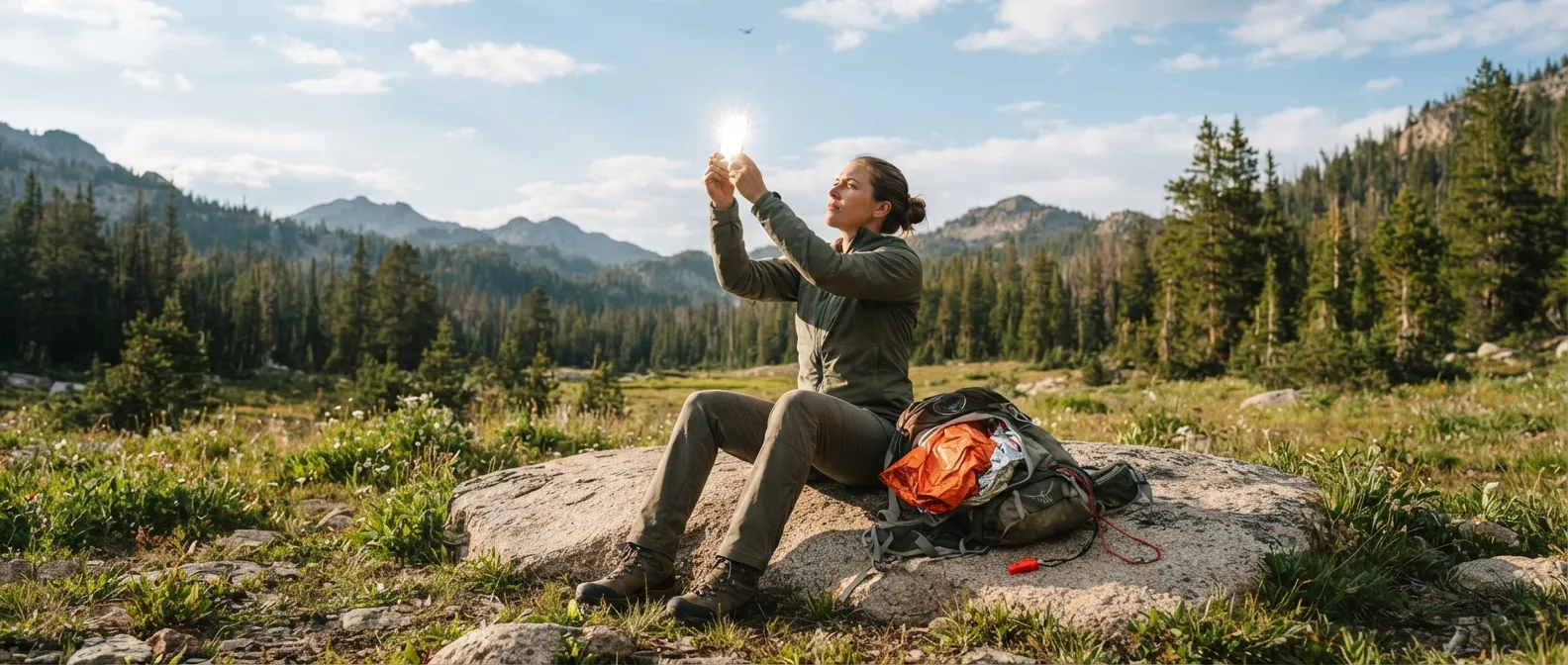
Under clear skies, few emergency tools outperform a signal mirror, and it never runs out of battery. The US Army Survival Manual (FM 21-76) details the operation of the military MK-3 model, which features a central sighting hole: reflect sunlight onto a nearby surface (like your hand), bring the mirror up to eye level, and look through the sight hole to spot a bright spot of light—this is your aiming reticle. Move the mirror to align that spot directly on your target (aircraft, vessel, or distant ridge). Without a specialized sight hole, the two-finger technique works as well: extend your free hand in a V-shape toward the target, aligning the reflected beam between your fingers.
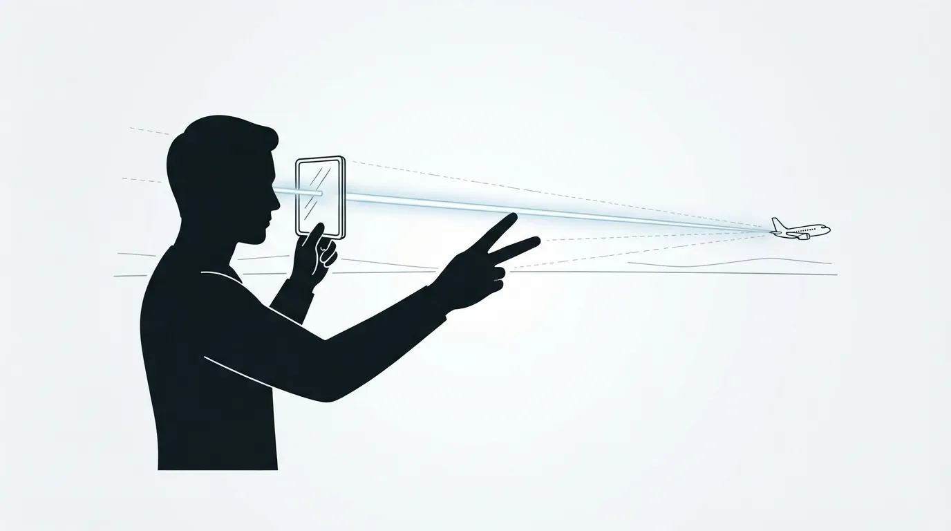
Under optimal atmospheric conditions—clear air, high altitude, zero haze—pilots have reported spotting mirror flashes from up to 160 kilometers (100 miles) away. Avoid flashing rapidly in erratic bursts: maintain a slow, steady cadence to avoid blending into natural reflections from water or snowpack.
For fires and smoke, the international distress standard centers on a single number: three. Three fires placed in a triangle, or arranged in a straight line spaced roughly 25 meters apart, form a universally recognized distress signal. At night, fire is the most effective visual signal available. By day, smoke takes priority: smother a hot fire with green foliage, moss, or damp vegetation to generate thick white smoke, or add rubber or oil-soaked rags for heavy black smoke—always choose a color that contrasts with the surrounding environment (dark smoke over snow, light smoke over dark woodland). Note that smoke signals are only effective in calm, clear conditions: wind, heavy rain, or snow will dissipate smoke before search aircraft can spot it.
On the ground, using high-contrast materials (tarps, bright clothing, rocks, logs, or trampled snow), the international ground-to-air visual code uses simple geometric symbols. Panels should measure at least one meter in width and six meters in length, maintaining a 1-to-6 proportions ratio:
| Symbol | Meaning | |
|---|---|---|
| V | Require assistance | |
| X | Require medical assistance | |
| N | No (negative) | |
| Y | Yes (affirmative) | |
| Arrow → | Proceeding in this direction |
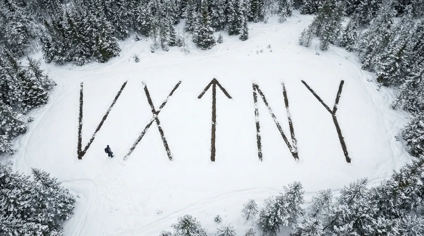
Construct these signals using whatever is at hand—orange tarps, dark branches against snow, light rocks against grass—in an open area clearly visible from above, away from tree cover. International orange is the standard color for distress: laying out an orange sleeping bag, tarp, or space blanket in a clearing—even without forming letters—immediately alerts a pilot scanning for unnatural colors in the environment.
Audio signaling and nighttime techniques
A whistle carries far beyond the human voice, which tires in minutes and rarely travels beyond 500 meters even when shouting at full capacity in open terrain. Under tested field conditions, standard pea-less whistles have been heard up to 1.6 kilometers (1 mile) away. The international protocol, which also applies to flashlights and mirrors at night, uses a distinct rhythm: three blasts, a pause, three blasts, repeated continuously until answered—rescuers respond with a set of three signals. The Morse code SOS (three dots, three dashes, three dots, sent without pauses between letters) follows the same rule of three, whether signaled by whistle, flashlight, or mirror. Practice this pattern using our interactive Morse tool before you ever need it in the field.
- Setting a headlamp to strobe mode catches attention far better than a solid beam, which easily gets mistaken for a star or distant cabin light. Sweep the beam along the horizon, not straight up into the sky.
- Fire remains the most powerful visual signal at night—visible at vast distances without draining battery power.
- Lasers attract attention across immense distances, but must never be pointed directly at an aircraft cockpit: even a low-power beam can dazzle or blind a pilot during critical flight operations. Sweep the beam side-to-side across the horizon instead of aiming straight at the aircraft.
- Banging three times on a trunk or rock wall echoes effectively through canyons, ravines, or caves where whistle blasts and voices get muffled.
What to do when the helicopter arrives
When a rescue helicopter approaches, standard safety procedures apply across both land and sea: secure any loose items that could fly away (tarps, unzipped packs, light clothing), stand still and clearly visible in an open space, and wait for a direct signal from the flight crew before moving toward the aircraft. Face the helicopter and use two simple body signals: extending both arms upward in a Y shape means “Yes, I need assistance”; extending one arm up and one arm down diagonally means “No, no assistance required.” Hold the pose completely still—this sets a distress signal apart from someone casually waving at a passing aircraft—and position yourself with your back to the wind whenever possible: pilots need to gauge wind direction to land or hover, which can be difficult to determine from the air.
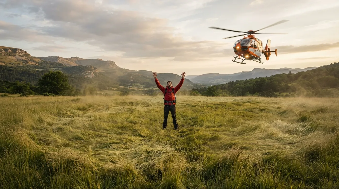
Never approach a helicopter on your own initiative, even if you intend to assist: stay where the crew can see you, and wait for them to approach you or signal you forward. Military survival manuals give the same directive for maritime hoist operations, which applies directly to mountain rescues: secure all loose gear before the recovery gear lowers, hold your ground unless directed otherwise, and follow every instruction from the rescue crew—their commands supersede your judgment, even when they seem counterintuitive.
At sea, signaling principles closely mirror land procedures—mirrors, flares, EPIRBs—but carry unique priorities (such as staying with the vessel or life raft rather than attempting to swim for shore): see our full guide on maritime survival for detailed procedures.
In a group, never split up to search individually once lost: a group is easier to spot from the air, stays warmer, and is far simpler to locate than isolated individuals. Splitting up multiplies the number of Last Known Points rescuers must search. Instead, designate one person to remain at camp while a second individual—only if absolutely necessary—scouts nearby high ground for cell coverage, never going alone and always setting a strict return time.
The ideal waiting area combines two key elements that rarely occur together naturally: high visibility from the air (a clearing, ridge line, or riverbank) and adequate shelter to endure hours without suffering hypothermia or exhaustion. If you cannot find both in one spot, establish a primary camp near shelter and set up a secondary signal station a few dozen meters away in the open—never hide completely in dense cover just to stay out of the wind.
Moving despite being lost is only justified under specific conditions: no one knows your route or expected return time, immediate environmental hazards threaten your location (flash floods, rockfalls, wildfires), or a confirmed water source and shelter are a short, guaranteed distance away. If you must move, follow a distinct handrail feature—such as a stream downhill or a ridge line—never a vague compass bearing, and leave obvious trail markers behind you as you move.
After you are rescued, your job isn’t finished: immediately notify every contact you alerted before your trip so they can cancel active or pending search requests—first responders sometimes continue searching for someone who has already made it home safely simply because no one called off the search. Keep in mind that helicopter evacuations in mountain areas can cost between €2,000 and €5,000 in France if not covered by insurance: joining an alpine federation, which usually costs around €24 per year, often includes search and rescue coverage.
Frequently asked questions
Should you really stay put when you get lost?
Yes, in the vast majority of cases, especially if someone knows your planned route and expected return time: a stationary, visible target is located far faster than a moving one. Kenneth Hill’s study of 800 missing person cases revealed that almost no one stays put spontaneously, which dramatically lengthens search operations.
Does dialing 112 really work without cell service?
It works without service from your specific provider by automatically routing through any active network in the area—however, it cannot connect in dead zones where no towers from any carrier exist. A text message requires much less signal strength than a voice call and can sometimes go through where voice calls fail.
How does satellite SOS work on modern smartphones?
On an iPhone 14 or newer (and equivalent Android devices), when neither cellular nor Wi-Fi networks are available, the phone prompts you to launch Emergency SOS via satellite. It guides you onscreen to point at a passing satellite, then automatically transmits your coordinates, altitude, Medical ID, and answers to a brief emergency questionnaire. Heavy forest cover or steep cliffs can still block the signal.
What is the main difference between a PLB and a satellite messenger like an inReach?
A PLB sends a one-way emergency signal via the Cospas-Sarsat satellite network, requires no subscription fees, offers free registration, and works globally. A two-way messenger like a Garmin inReach or Zoleo allows you to send and receive text messages via the Iridium network, but requires an active monthly subscription plan.
How do you properly signal a rescue helicopter?
Stand completely still in an open clearing, ideally with the wind at your back, and extend both arms straight up in a Y shape to signal that you need assistance (holding one arm up and one down diagonally signals that you are fine). Secure all loose gear before the aircraft arrives, and never approach the helicopter until explicitly signaled by the crew.
Can a regular campfire serve as a distress signal?
Not on its own: a single campfire looks identical to a standard campsite and will not trigger a rescue response. International distress protocol relies on patterns of three—three fires in a triangle or line, three smoke plumes, three whistle blasts—because a repeated set of three is recognized globally as an intentional cry for help, whereas a single signal remains ambiguous.
Key takeaways
- Staying put near your Last Known Point while remaining visible is almost always the best strategy: search teams focus their efforts there first, and a stationary target is found much faster than a moving one.
- Leaving a trip plan before setting out (route, return time, emergency contact deadline) is the single most effective safety step: it dictates when search efforts actually begin.
- Your phone still offers emergency options without regular service: 112 emergency roaming, text messaging, gaining elevation for signal, or satellite SOS on newer smartphones.
- A registered PLB works worldwide without subscription fees; a two-way satellite messenger like a Zoleo or inReach adds text communication capabilities in exchange for a monthly plan.
- The number three is the universal language of distress—three fires, three whistle blasts, three mirror flashes—and a well-aimed mirror often carries further than a flare.
Going further
- Robert J. Koester, Lost Person Behavior (dbS Productions, 2008) — the definitive global reference on where to search based on who is lost.
- Kenneth Hill, The Psychology of Lost — the seminal study explaining why almost no one stays put when lost.
- Check out the signaling comparison guide to choose gear based on range, weight, and cost.
- Visit the tools page to practice Morse code rhythms before heading out into the field.
Sources for this module (22)
- Robert J. Koester, Lost Person Behavior (dbS Productions, 2008) — base ISRID
- UVA Today — Meet the World's Preeminent Expert in Lost Person Behavior
- Kenneth Hill, The Psychology of Lost (Saint Mary's University)
- Alpine Rescue Team — Hug-A-Tree and Survive
- FM 21-76 US Army Survival Manual, ch. 19 « Signaling Techniques »
- Wikipedia (EN) — Getting lost
- Wikipedia (EN) — Distress signal
- Wikipedia (EN) — Emergency position-indicating radio beacon
- Wikipedia (EN) — Signal mirror
- Wikipedia (EN) — What3words
- Wikipedia (EN) — 112 (emergency telephone number)
- Wikipédia (FR) — Numéro d'urgence (le 114 pour les sourds et malentendants)
- Wikipédia (FR) — Unités de montagne de la Gendarmerie nationale (PGHM)
- Wikipedia (EN) — Rega (Garde aérienne suisse de sauvetage)
- Wikipedia (EN) — Search dog
- Wikipedia (EN) — Berkshire Lowland Search and Rescue (drones thermiques)
- Wikipedia (EN) — Lasers and aviation safety
- Apple — Emergency SOS via satellite
- ANENA — Association nationale pour l'étude de la neige et des avalanches
- ZOLEO — messager satellite bidirectionnel
- Yaute Rando — Les signaux de détresse universels en montagne
- Sentier Nature — Alerter les secours en montagne, du 112 aux systèmes satellitaires
Continue in "The fundamentals"

Mindset: the key to everything
Before fire, before water, before shelter: what happens in your head during the first ten minutes.
Water: Finding, collecting, and making it drinkable
Three days without water is the popular myth. The real question is where it's hiding and what's inside it.
Fire: light it anywhere, keep it always
In the rain, on the snow, without a lighter: the physics of fire, techniques that work, and those that only work in the movies.